DEVELOPMENT PLANNING CONCERNS OF THE COUNTRY - a letter to the New Prime Minister
This letter was sent to the new Prime Minister, Shri Narendra Modi, from my father who has been a Professor of Urban Planning at the School of Planning and Architecture. He lists seven aspects about urbanization and development in India that he believes the Modi government should closely consider : -
Honourable Prime Minister Shri Narendra Modi ji,
As Team Leader of the project Perspective Plan for Delhi Mumbai Industrial Corridor (DMIC), of the Central Government, I visited Gujarat Government in 2010, seeking its approval. I was pleasantly surprised to be told that the proposals were in line with the vision of the Hon’ble CM and I should make a presentation before him. However, due to preoccupation he could not spare time for the presentation. But eventually the proposals were approved and I felt greatly honoured and professionally satisfied.
With such personal experience and encouraged by your determined pro-active instance, a visionary doer’s image, and creation of country wide environment of inspired hope of effective and real-time development, I endeavor to suggest the following concerns and ways forward -
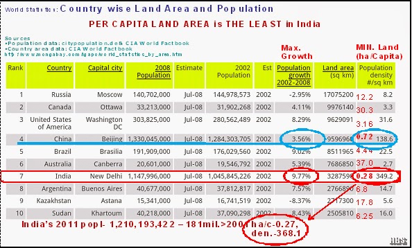
The social welfare of the people through Economy, Employment and Equity is definitely the most important aspect of development. But equally important is availability of land to accommodate teaming population for its living, working, movement and socialization for leading good quality of life. India has the least area of land per person 0.28 ha/person lesser than even China with 0.72ha/p. The problem is further aggravated with the maximum rate of growth population in India (9.77 %) bringing further down the land per person to 0.27 ha/person in 2013. This figure being the least in the world should serve as an eye opener to planning professionals and the Government of India.
According to Population Reference Bureau Washington, 2002 world Population Data Sheet, India on its 2 percent world’s geographical area, 4 percent fresh water resources, and only 1.7 percent forest area carries 18 percent of human population and 15 percent of world’s domestic animals.This puts enormous pressure on environment and threatens ecological balance. Further, the urbanisation level is the least and many development parameters are very low just above the Africa.

For professional planning, it is required to have the following three key components:
(i) Development Policy. First, based on statistical data, related to issues and potentials which is then translated in;
(ii) Spatial Plans - Area (National, State, Regional / Division), sub- regional / District - Nodes (Urban and Rural centres) and Networks of infrastructure including transportation. It is only after, these two have been established that;
(iii) Programmes / Projects are designed for effective implementation, as they are well rooted contextually through planning.
Unfortunately in our country, after preparing a Development Policy, we go straight to Programmes/ Projects bye-passing the second stage of Planning, resulting in failures or ineffectiveness of Projects. This may be due to the ruling party’s eagerness to show results within their tenure, or due to traditionally ignoring / conveniently forgetting the Spatial Planning.
Planning for effective national development should integrate time (long term perspective, 5 year Plans (FYP), Annual Plans) and space, macro and micro aspects, in the form of Policy, Plan and Programmes/Projects. This is to ensure continuity of developmental efforts and mitigation of disjointedness of government’s FYP (or ruling party’s own FYP) to make definite progress in the perceived long term direction of development.
At present there is no professional input of planners in the functioning of Planning Commission. There are many scholars of repute from various fields related to development but not of Planning as such. This is, in spite of the fact that there are 14 Institutions imparting education and training in physical planning from Bachelors level to Masters and PhD in the country.
It is a known fact that if there is no synchronization among above mentioned areas, development efforts are ineffective, and projects are difficult to implement. Sometimes constituencies divide a district among themselves making District Planning a difficult task. So is the case of presently dis-functioning NCR wherein one cannot reach one’s destination in Ghaziabad, Noida or Faridabad from New Delhi railway station without paying a tax (legal or illegal) at the border.
It may be worthwhile to consider synchronizing boundaries of Loksabha constituencies (543) to districts (640) and Vidhansabha constituencies to Development Blocks. This should not only facilitate successful district planning and preparation of Master Plans / projects, but should increase the sense of ownership of development efforts by all stake holders for effective implementation.
The physical and spatial integration in terms of Urban Nodes, Rural Area and Network of infrastructure, is needed to be planned together in a regional planning framework before their Master Plans are evolved. The envisaged 100 new smart cities must consider the regional planning framework for their location, well worked out economic base, along-with physical and functional linkage with their resource region to ensure its mutually beneficial role in its hinterland.
There is need to consider formation of a Ministry of Urbanisation and Regional Planning to monitor and coordinate Spatial Planning from National level - down to District and village level. This may be done emphasizing adoption of 73rd & 74th Constitutional Amendment Acts by all State Governments. Equally important is to come out with Urbanisation Policy and National Landuse Policy by Planning Commission to have a meaningful rural urban continuum.
Negative implication of urbanization in the form of overcrowding, squatting and slum formation etc. can be taken care of by having regional planning approach of having not only curative measures at the urban centres but also simultaneous preventive measures in rural areas from where migrants come.
I hope you will be kind enough to acknowledge my concerns, and consider them in your quest for the development of the nation.
Sincerely,
H.B.Singh
Re: DEVELOPMENT PLANNING CONCERNS OF THE COUNTRY
Honourable Prime Minister Shri Narendra Modi ji,
As Team Leader of the project Perspective Plan for Delhi Mumbai Industrial Corridor (DMIC), of the Central Government, I visited Gujarat Government in 2010, seeking its approval. I was pleasantly surprised to be told that the proposals were in line with the vision of the Hon’ble CM and I should make a presentation before him. However, due to preoccupation he could not spare time for the presentation. But eventually the proposals were approved and I felt greatly honoured and professionally satisfied.
With such personal experience and encouraged by your determined pro-active instance, a visionary doer’s image, and creation of country wide environment of inspired hope of effective and real-time development, I endeavor to suggest the following concerns and ways forward -
Per Capita Land Area is Minimum in India among Large Countries of the World
The social welfare of the people through Economy, Employment and Equity is definitely the most important aspect of development. But equally important is availability of land to accommodate teaming population for its living, working, movement and socialization for leading good quality of life. India has the least area of land per person 0.28 ha/person lesser than even China with 0.72ha/p. The problem is further aggravated with the maximum rate of growth population in India (9.77 %) bringing further down the land per person to 0.27 ha/person in 2013. This figure being the least in the world should serve as an eye opener to planning professionals and the Government of India.
Sustainability Concerns
According to Population Reference Bureau Washington, 2002 world Population Data Sheet, India on its 2 percent world’s geographical area, 4 percent fresh water resources, and only 1.7 percent forest area carries 18 percent of human population and 15 percent of world’s domestic animals.This puts enormous pressure on environment and threatens ecological balance. Further, the urbanisation level is the least and many development parameters are very low just above the Africa.
No adequate Physical Planning to ensure Effective Development on the ground
For professional planning, it is required to have the following three key components:
(i) Development Policy. First, based on statistical data, related to issues and potentials which is then translated in;
(ii) Spatial Plans - Area (National, State, Regional / Division), sub- regional / District - Nodes (Urban and Rural centres) and Networks of infrastructure including transportation. It is only after, these two have been established that;
(iii) Programmes / Projects are designed for effective implementation, as they are well rooted contextually through planning.
Unfortunately in our country, after preparing a Development Policy, we go straight to Programmes/ Projects bye-passing the second stage of Planning, resulting in failures or ineffectiveness of Projects. This may be due to the ruling party’s eagerness to show results within their tenure, or due to traditionally ignoring / conveniently forgetting the Spatial Planning.
Planning for effective national development should integrate time (long term perspective, 5 year Plans (FYP), Annual Plans) and space, macro and micro aspects, in the form of Policy, Plan and Programmes/Projects. This is to ensure continuity of developmental efforts and mitigation of disjointedness of government’s FYP (or ruling party’s own FYP) to make definite progress in the perceived long term direction of development.
No professional input in Spatial Planning Process at the National Level
At present there is no professional input of planners in the functioning of Planning Commission. There are many scholars of repute from various fields related to development but not of Planning as such. This is, in spite of the fact that there are 14 Institutions imparting education and training in physical planning from Bachelors level to Masters and PhD in the country.
Jurisdictional Mismatch of Geographical Boundaries among Administrative, Legislative Constituencies and Planning Areas
It is a known fact that if there is no synchronization among above mentioned areas, development efforts are ineffective, and projects are difficult to implement. Sometimes constituencies divide a district among themselves making District Planning a difficult task. So is the case of presently dis-functioning NCR wherein one cannot reach one’s destination in Ghaziabad, Noida or Faridabad from New Delhi railway station without paying a tax (legal or illegal) at the border.
It may be worthwhile to consider synchronizing boundaries of Loksabha constituencies (543) to districts (640) and Vidhansabha constituencies to Development Blocks. This should not only facilitate successful district planning and preparation of Master Plans / projects, but should increase the sense of ownership of development efforts by all stake holders for effective implementation.
Envisaged 100 New Smart Cities
The physical and spatial integration in terms of Urban Nodes, Rural Area and Network of infrastructure, is needed to be planned together in a regional planning framework before their Master Plans are evolved. The envisaged 100 new smart cities must consider the regional planning framework for their location, well worked out economic base, along-with physical and functional linkage with their resource region to ensure its mutually beneficial role in its hinterland.
Ministry of Urbanisation and Regional Planning
There is need to consider formation of a Ministry of Urbanisation and Regional Planning to monitor and coordinate Spatial Planning from National level - down to District and village level. This may be done emphasizing adoption of 73rd & 74th Constitutional Amendment Acts by all State Governments. Equally important is to come out with Urbanisation Policy and National Landuse Policy by Planning Commission to have a meaningful rural urban continuum.
Negative implication of urbanization in the form of overcrowding, squatting and slum formation etc. can be taken care of by having regional planning approach of having not only curative measures at the urban centres but also simultaneous preventive measures in rural areas from where migrants come.
I hope you will be kind enough to acknowledge my concerns, and consider them in your quest for the development of the nation.
Sincerely,
H.B.Singh


Excellent . just hope someone is listening and take it further . very true , unless we have a FYP - of physical plan and not just a economic plan this will be on paper . if this vision has to turn to reality , this has to translated into reality .
ReplyDeleteTruly hope that someone is listening. Spatial Plans currently being limited to the regional (district level) must be topped with State Level as well as National Level Spatial Plans. The absence of such may reduce the effectiveness of large scale projects like the DMIC which transcend any statutory spatial planning. State-Level Plans would ensure that state capitals are linked not only to their metropolitan areas but to the rest of the state for which they serve as primate-cities. This task is currently left to PWD and NHAI which are merely transportation bodies.
ReplyDelete